Every large wildfire starts as a small one. A spark from a power line on a windy afternoon, a cigarette tossed from a car, or a hot exhaust pipe in dry grass can each start something that fits under a bucket. Left alone for twenty minutes in the wrong weather, the same fire can cover acres.
That gap between ignition and the first report is where newer detection technology tries to help. This article looks at one example, the FireSense Portal from Lindsey FireSense, LLC, and the FIREBird sensors behind it. We’ll go through what the system is, how it works, who it’s for, and what it can and can’t do.
A note on sources: Most technical specifications here come from Lindsey FireSense’s own published materials and public testimony. They are manufacturer claims, not independently verified test results.
Why early detection matters so much
Wildfire spread isn’t linear. A fire that starts in light, dry fuel with wind behind it can grow very fast, and every minute it goes unnoticed costs responders options. Three things make early detection valuable:
- Small fires are easier to stop. A fire caught while it’s still a spot fire can often be put out by one engine crew. A fire caught later may need aircraft, many crews, and evacuations.
- Human reporting is unreliable. Fires in remote areas, at night, or along empty roads can burn a while before anyone sees them and calls 911.
- The riskiest conditions are also the fastest-spreading ones. Lindsey FireSense has made this point in testimony to the California Senate: the strong wind events that can make power lines arc or fail are the same ones that push fire fastest. Research the company cited suggests power-line-caused fires tend to grow larger than fires from other causes.
Automated, always-on sensors are meant to close that reporting gap.
What is FIREBird?
FIREBird is a compact early wildfire detection device made by Lindsey FireSense, LLC, based in Azusa, California. It’s mainly designed to mount on utility poles, but it can also go on buildings, streetlights, and similar structures along what the company calls “critical boundaries”: power lines, roadways, and the edge where wildland meets homes.
According to the company, each unit includes:
- Thermal (heat) detectors tuned for wildfire. The company’s current materials describe 360-degree coverage from 14 combined thermal detectors and optical cameras. Earlier testimony described 6 thermal detectors and 8 optical cameras.
- Optical cameras that capture images of a suspected fire so a person can confirm it visually.
- Weather instruments that measure wind speed, wind direction, temperature, and humidity, the main variables in fire behavior.
Why heat detection instead of smoke?
Many people picture fire detection as smoke detection, but outdoors smoke is a poor signal: it disperses, drifts, and is hard to see at night or in fog. FIREBird uses heat signatures, which the company says works day or night and in most atmospheric conditions.
How far can it “see”?
The company’s published figures:
- Detection of very small fires up to about 400 feet away
- Detection of larger fires out to roughly 900 feet
- Earlier testimony described a radius of almost 1,000 feet, or about a 60-acre detection zone per device
That’s a local, close-range design. Its aim is to catch ignitions right where they’re most likely to start, such as under a power line or beside a road, not to watch an entire mountainside.
What is the FireSense Portal?
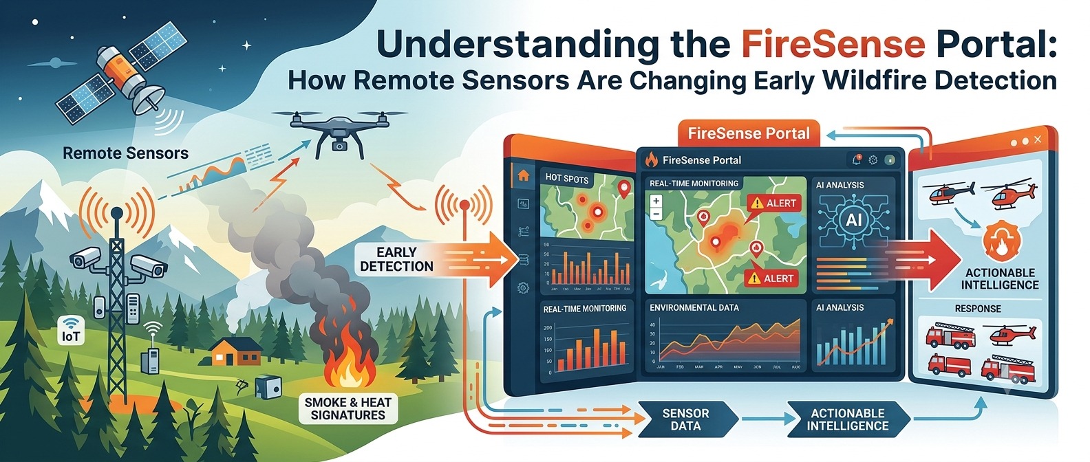
Sensors are only useful if the right people get their data quickly. The FireSense Portal is the web-based dashboard that connects FIREBird devices to their operators, such as utility staff, fire departments, city emergency managers, or private property owners.
The company says the portal works the same way whether you manage one device or a thousand. Here are its main features as described by the manufacturer.
1. A single view of every device
The portal opens to a summary of all connected FIREBird units, so an operator can see the status of the whole network at once instead of checking each sensor.
2. One-click fire map
One click brings up a map of all devices, with any reporting active fires highlighted. In an emergency, this answers the first question responders ask: where is it?
3. Per-device detail
For each device, users can see:
- Fire and heat alarms
- Live and historical weather data (wind, temperature, humidity)
- Notification history
- Camera images from the device
4. Map overlays for context
The map can show active fires, Red Flag zones, and real-time weather. Red Flag Warnings are issued when warm temperatures, very low humidity, and strong winds combine to create high fire danger, so this overlay helps operators judge how serious an alert is .
5. Automated alerts
When a FIREBird detects a probable fire, the system automatically notifies the people assigned to that device. The company says this usually happens within about two minutes of detection. Alerts:
- Arrive by text message and email
- Include images of the suspected fire for quick visual confirmation
- Go to contact groups set up per device, such as a utility control room, a monitoring company, or local first responders
6. Features for utilities
Because FIREBird is often mounted along power lines, the portal includes tools for electric utilities:
- “Line view” cameras pointed along the utility right-of-way, letting operators inspect the lines and the vegetation around them
- A “PSPS Clear” feature that supports the end of Public Safety Power Shutoff (PSPS) events
What’s a PSPS? In high-risk weather, some utilities, especially in California, cut power to certain lines on purpose to avoid sparking a fire. Before turning power back on, crews must confirm the lines are undamaged and no fire is burning. Remote cameras and sensors may help with that check, which can shorten outages for the communities affected .
7. Mobile access and “Follow Me”
The portal runs in a standard web browser and is designed to work on phones. The company also describes a “Follow Me” feature that sends alerts about fires near the user’s current location, which is useful for field crews and supervisors on the move.
How it all works together: a simple walkthrough
Here’s how the pieces connect in a typical alert:
- Ignition: A small fire starts in dry grass under a power line.
- Detection: A nearby FIREBird’s thermal detectors pick up the heat signature.
- Capture: The device’s cameras take images and its weather sensors log current wind and humidity.
- Notification: Within a couple of minutes, the assigned contacts get a text and email with images and the location.
- Verification: An operator opens the FireSense Portal, sees the fire on the map, checks the photos and wind direction, and confirms it’s a real fire.
- Response: First responders are sent out while the fire is still small, ideally before it can spread.
The main value is in step 4: getting from ignition to an alert in minutes rather than waiting for someone to happen to see it.
Who uses systems like this?
- Electricutilitiesthat need to monitor high-risk lines and manage PSPS events
- Fire departments and fire protection districts that want earlier warning in high-risk zones
- Cities and counties protecting neighborhoods on the wildland-urban interface
- Transportation agencies watching roadsides, a common place for fires to start
- Large property owners, such as campuses, industrial sites, and ranches, near wildland
The company’s technology has been field-tested in Southern California, including a controlled-burn demonstration with local firefighters. Rancho Cucamonga has been reported as the first California community to deploy the FIREBird system with state funding.
Limitations to keep in mind
No single technology solves the wildfire problem. If you’re evaluating any detection system, ask about these:
- Coverage is local. A range of a few hundred to about a thousand feet per device means covering large areas takes many units. Systems like this complement satellites, camera towers, and human lookouts; they don’t replace them.
- Detection isn’t suppression. An alert only helps if someone can respond to it quickly.
- False alarms and missed detections. All sensors make trade-offs. Ask vendors for independent field data on accuracy under real conditions.
- Power and connectivity. Remote sensors need reliable power and communications, especially during the storms and outages when they matter most.
- Vendor claims vs. independent validation. Many published specifications, including the ones in this article, come from the manufacturer.
The bigger picture
Wildfire detection is moving away from relying only on chance sightings toward layered, always-on networks: satellites for broad coverage, ridge-top cameras for long-range views, and close-range sensors like FIREBird at the places fires most often start. Web portals like FireSense pull that sensor data into one shared view so the people responsible can act on it quickly.
For residents of fire-prone regions, the main point is that the first few minutes of a wildfire matter most. Whether the warning comes from a sensor, a neighbor, or you, quick reporting is the most effective tool anyone has.
Quick safety reminders
- Call 911 right away if you see smoke or flames. Don’t assume someone else already has.
- Sign up for your county’s emergency alert system.
- Keep defensible space around your home and have an evacuation plan ready.
- Watch for Red Flag Warnings and avoid activities that can cause sparks on those days.
Key takeaways
- FIREBird is a pole-mounted wildfire detection device that combines thermal detectors, optical cameras, and weather sensors.
- The FireSense Portal is its web dashboard, with device status, fire maps, weather overlays, camera images, and automated text and email alerts.
- The system is aimed at fast, local detection where fires most often start: power lines, roads, and the wildland-urban interface.Utility-specific features such as line-view cameras and PSPS Clear support safer power shutoff and restoration decisions.
- Utility-specific features such as line-view cameras and PSPS Clear support safer power shutoff and restoration decisions.
- Like any single tool, it works best as one layer of a broader wildfire preparedness strategy.
This article is for educational and informational purposes. It is not sponsored by or affiliated with Lindsey FireSense, LLC. Product details are based on publicly available information from the manufacturer and news coverage; bracketed numbers refer to the References list. Contact the company directly for current specifications.
References
- Lindsey FireSense, LLC. “FireSense Portal.” https://lindsey-firesense.com/firesense-portal/
- Lindsey FireSense, LLC. “Tour the FIREBird.” https://lindsey-firesense.com/tour/
- McCall, J. “Remarks of Jack McCall of Lindsey FireSense, LLC.” Testimony to the California State Senate.
- Fire & Safety Journal Americas. “California’s first FIREBird early wildfire detection system.” https://fireandsafetyjournalamericas.com/firebird-wildfire-detection/
- T&D World. “Lindsey FireSense LLC” (wildfire mitigation directory). https://www.tdworld.com/directory/wildfire-mitigation/company/21252082/lindsey-firesense-llc
- ABC7 Los Angeles. “During fire season, this new piece of technology may be key to saving homes and lives.” https://abc7.com/this-device-may-be-key-to-saving-lives-homes-in-fire-season/10744943/
- Kurrant. “Rancho Cucamonga To Unveil California’s State-Funded Wildfire System.” https://kurrant.com/kurrantly-news/rancho-cucamonga-to-unveil-californias-state-funded-wildfire-system/